Fayl:Mosques in Cairo showing different direction.png
Navigatsiya qismiga oʻtish
Qidirish qismiga oʻtish
Bu prevyuning hajmi: 564 × 600 piksel. Boshqa oʻlchamlari: 226 × 240 piksel | 451 × 480 piksel | 739 × 786 piksel.
Asl fayl (739 × 786 piksel, fayl hajmi: 160 KB, MIME tipi: image/png)
Qisqa izoh
| Description |
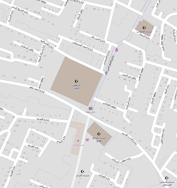
A modern map of part of Cairo showing mosques with different qibla directions. This map of Cairo was created from OpenStreetMap project data, collected by the community. This map may be incomplete, and may contain errors. Don't rely solely on it for navigation. |
|||||||||
| Sanasi | ||||||||||
| Manba | openstreetmap.org | |||||||||
| Yaratuvchi |
OpenStreetMap contributors |
|||||||||
| Ruxsat (Bu faylning takror foydalanilishi) |
OpenStreetMap data is available under the Open Database License (details). Map tiles are licensed under the Creative Commons Attribution-ShareAlike 2.0 license (CC-BY-SA 2.0).
This file is licensed under the Creative Commons Attribution-Share Alike 2.0 Generic license.
|
|||||||||
| Geotemporal data | ||||||||||
| Bounding box |
|
|||||||||
| Georeferencing | If inappropriate please set warp_status = skip to hide. | |||||||||
Fayl tarixi
Faylning biror paytdagi holatini koʻrish uchun tegishli sana/vaqtga bosingiz.
| Sana/Vaqt | Miniatura | Oʻlchamlari | Foydalanuvchi | Izoh | |
|---|---|---|---|---|---|
| joriy | 03:19, 2019-yil 26-dekabr | | 739 × 786 (160 KB) | wikimediacommons>HaEr48 | {{OpenStreetMap |name = |location = Cairo |description = A modern map of part of Cairo showing mosques with different qibla directions. |top = 30.04492 |bottom = 30.04128 |left = 31.25578 |right = 31.25976 |date = 2019-12-26 |authors = |other_versions = |warp_status = |warp_url = |other_fields = }} Category:OpenStreetMap maps of Egypt Category:Qibla Category:Maps of Cairo |
Fayllarga ishoratlar
Bu faylga quyidagi sahifa bogʻlangan: